
Fichièr:CEM-36-Regno-di-Nivche-2429.jpg

Talha d'aquesta previsualizacion: 800 × 593 pixèls. Autras resolucions : 320 × 237 pixèls | 640 × 474 pixèls | 1 024 × 759 pixèls | 1 280 × 949 pixèls | 1 600 × 1 186 pixèls.
Fichièr d'origina (1 600 × 1 186 pixèl, talha del fichièr: 1,07 Mo, tipe MIME: image/jpeg)
| Aqueste fichièr proven de Wikimedia Commons?. Las informacions que lo concernisson son afichadas çaijós (procedura). |
Descripcion
| Descripcion |
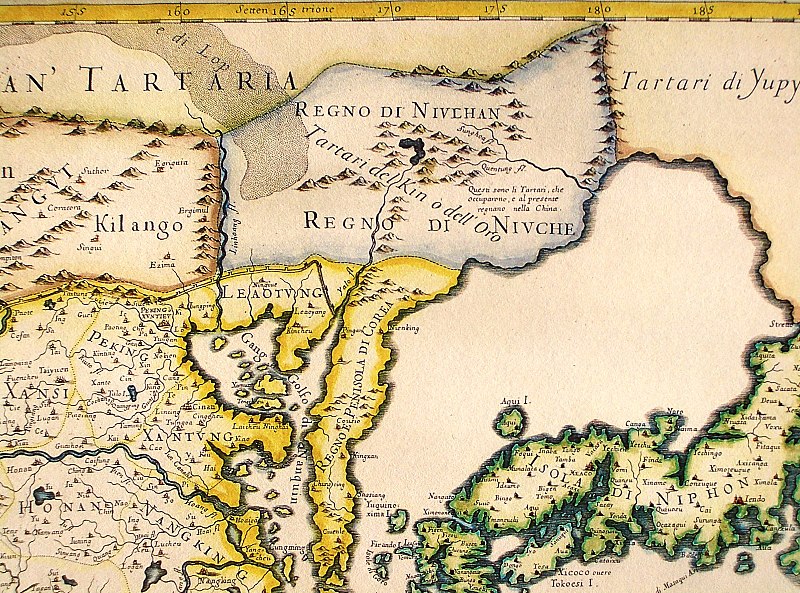
English: Northeastern fragment of a map of China (in Italian), showing the "Tartari del Kin o dell'Oro" (i.e., the Jin Tartars, or the Golden Tartars) populating the "Regno del Niulhan" (?) a.k.a. "Regno del Niuche" (i.e. the Kingdom of the Nüzhen, a.k.a Jurchen") who are further described as "The Tartars who have occupied, and at present are ruling, China". Further northeast, the "Tartari de Yupy" (i.e., "Fishskin Tartars" - the generic name of the Tungusic people of the Amur) are shown.
Italiano: "Il regno della China detto presentemente Catay e Mangin diuiso sopra le carte piu esatte nelle sue principali prouincie" |
| Data | Originally published 1682; the copy at HKUST is a 1689 reprint. |
| Font |
English: An antique map from the Special Collection "China in Maps" of the Hong Kong University of Science and Technology Library, reproduced by the HKUST Library in the book "China in European Maps", Hong Kong, 2003. ISBN 962-86403-9-9.
Русский: Старинная карта из специальной коллекции Библиотеки Гонконгского научно-технического университета. Опубликована этой библиотекой в книге "China in European Maps" (Китай на европейских картах), Гонконг, 2003. ISBN 962-86403-9-9, тиражом 1000 экз. См. также каталог выставки, Special Collection "China in Maps".
. Fragment of Plate 36: "Il regno della China detto presentemente Catay e Mangin diuiso sopra le carte piu esatte nelle sue principali prouincie" |
| Autor | Giacomo Cantelli (1643-1695), Giovanni Giacomo de Rossi (1627-1691) |
| Autras versions |
Entire map:  |
Publicat jos licéncia(s)
|
Això és una mera fotografia d'una obra d'art bidimensional en domini públic. L'obra d'art original és en domini públic pel següent motiu:
La posició oficial de la Fundació Wikimedia és que «les reproduccions fidels d'obres d'art bidimensionals de domini públic són en domini públic».
Per tant, aquesta reproducció fotogràfica també es considera en domini públic als Estats Units. En altres jurisdiccions la reutilització d'aquest contingut pot estar restringida; vegeu Reuse of PD-Art photographs per a més informació. | ||||
Istoric del fichièr
Clicar sus una data e una ora per veire lo fichièr tal coma èra a aqueste moment
| Data e ora | Miniatura | Dimensions | Utilizaire | Comentari | |
|---|---|---|---|---|---|
| actual | 12 agost de 2013 a 12.40 | | 1 600×1 186 (1,07 Mo) | Soerfm | Crop, brightness |
| 18 març de 2009 a 04.06 |  | 1 600×1 200 (1 024 Ko) | Vmenkov | {{Information |Description={{en|1=Northeastern fragment of a 1682 map of China (in Italian), showing the "Tartari del Kin o dell'Oro" (i.e., the Jin Tartars, or the Golden Tartars) populating the "Regno del Niulhan" (?) a.k.a. "Regno del Niuche" (i.e. the |
Paginas que contenon lo fichièr
La pagina çaijós compòrta aqueste imatge :
Usatge global del fichièr
Los autres wikis seguents utilizan aqueste imatge :
- Utilizacion sus bcl.wikipedia.org
- Utilizacion sus bg.wikipedia.org
- Utilizacion sus en.wikipedia.org
- Utilizacion sus es.wikipedia.org
- Utilizacion sus fr.wikipedia.org
- Utilizacion sus gl.wikipedia.org
- Utilizacion sus gu.wikipedia.org
- Utilizacion sus hy.wikipedia.org
- Utilizacion sus id.wikipedia.org
- Utilizacion sus la.wikipedia.org
- Utilizacion sus nl.wikipedia.org
- Utilizacion sus pa.wikipedia.org
- Utilizacion sus pnb.wikipedia.org
- Utilizacion sus pt.wikipedia.org
- Utilizacion sus ro.wikipedia.org
- Utilizacion sus ru.wikipedia.org
- Utilizacion sus uk.wikipedia.org
- Utilizacion sus vi.wikipedia.org
- Utilizacion sus war.wikipedia.org
- Utilizacion sus zh.wikipedia.org