
Fichièr:Map of Israel, neighbours and occupied territories.svg

Talha d'aquesta previsualizacion PNG per aquest fichièr SVG: 465 × 600 pixèls. Autras resolucions : 186 × 240 pixèls | 372 × 480 pixèls | 595 × 768 pixèls | 794 × 1 024 pixèls | 1 588 × 2 048 pixèls | 559 × 721 pixèls.
Fichièr d'origina (Fichièr SVG, resolucion de 559 × 721 pixèls, talha : 650 Ko)
| Aqueste fichièr proven de Wikimedia Commons?. Las informacions que lo concernisson son afichadas çaijós (procedura). |
Descripcion
| Descripcion |
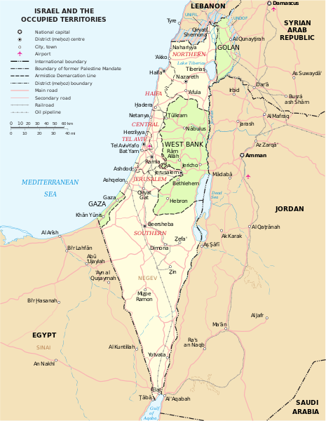
English: Map of the Middle East showing Israel, Egypt, Saudi Arabia, Jordan, Syria and Lebanon including Gaza, Golan Heights and West Bank.
العربية: خريطة دولة إسرائيل والأراضي الفلسطينية التي تشمل الضفة الغربية وقطاع غزة والجولان السوري المحتل. |
| Data | |
| Font | SVG extracted and edited from PDF |
| Autor | un.org |
| Autras versions | македонски |
| SVG information | Aqueste imatge vectorial es estat creat amb Inkscape. Cette carte SVG utilise du texte encapsulé qui peut être traduit facilement à l'aide d'un éditeur de texte. |
Publicat jos licéncia(s)
| Cette image est une carte dérivée de travaux de la Section de la Cartographie des Nations Unies (SCNU). Le nom de « Nations Unies » et le numéro de référence de la carte originale ne doivent pas apparaître sur les cartes dérivées. Un lien vers la carte originale doit être fourni. Les cartes de la SCNU modifiées sont considérées comme étant dans le domaine public. Ceci s'applique dans le monde entier. Les cartes des NU sont des documents open-source. Vous pouvez les utiliser pour faire vos propres cartes. Vous n'avez pas besoin de demander une autorisation explicite pour cela. Assurez-vous bien que le nom des NU et le numéro de référence de la carte originale ne figurent pas dans votre carte. Une carte des NU est un document des NU et ne peut être modifié. Vous pouvez écrire quelque chose comme « Basé sur la carte des Nations Unies numéro ... » -- Vladimir Bessarabov (UNCS Cartographer), 13 April 05 |
 |
| Jo, el titular del copyright d'aquesta obra, l'allibero al domini públic. Això s'aplica a tot el món. En alguns països això pot no ser legalment possible, en tal cas: Jo faig concessió a tothom del dret d'usar aquesta obra per a qualsevol propòsit, sense cap condició llevat d'aquelles requerides per la llei. |
Istoric del fichièr
Clicar sus una data e una ora per veire lo fichièr tal coma èra a aqueste moment
| Data e ora | Miniatura | Dimensions | Utilizaire | Comentari | |
|---|---|---|---|---|---|
| actual | 7 octobre de 2023 a 16.07 | | 559×721 (650 Ko) | LametinoWiki | File uploaded using svgtranslate tool (https://svgtranslate.toolforge.org/). Added translation for it. |
| 7 octobre de 2023 a 16.07 |  | 559×721 (650 Ko) | LametinoWiki | File uploaded using svgtranslate tool (https://svgtranslate.toolforge.org/). Added translation for it. | |
| 27 decembre de 2022 a 01.49 |  | 559×721 (596 Ko) | Wikijahnn | File uploaded using svgtranslate tool (https://svgtranslate.toolforge.org/). Added translation for ca. | |
| 27 decembre de 2022 a 01.46 |  | 559×721 (596 Ko) | Wikijahnn | File uploaded using svgtranslate tool (https://svgtranslate.toolforge.org/). Added translation for ca. | |
| 5 mai de 2018 a 17.09 |  | 559×721 (540 Ko) | FrankieF | Reverted to version as of 23:22, 5 March 2018 (UTC). Replaces a bad and blurred map without distance meter to a crisp and clear map. | |
| 10 març de 2018 a 18.47 |  | 559×721 (285 Ko) | Eric's son | The last version is outdated and factually incorrect. Reverted to version as of 21:50, 26 February 2018 (UTC) | |
| 5 març de 2018 a 23.22 |  | 559×721 (540 Ko) | Nableezy | Reverted to version as of 16:20, 12 December 2011 (UTC) make a different map, dont replace every other with this one | |
| 26 febrièr de 2018 a 21.50 |  | 559×721 (285 Ko) | Eric's son | small graphic fixes | |
| 19 febrièr de 2018 a 22.24 |  | 559×721 (259 Ko) | Eric's son | Adding relevant updates (evacuated UN zones), clear colored borders explained in legend. | |
| 12 decembre de 2011 a 16.20 |  | 559×721 (540 Ko) | Ch1902 | =={{int:filedesc}}== {{Information |Description={{en|1=Map of the Middle East showing Israel, Egypt, Saudi Arabia, Jordan, Syria and Lebanon including Gaza, Golan Heights and West Bank.}} |Source=SVG extracted and edited from [http://www.un.org/Depts/Car |
Paginas que contenon lo fichièr
I a ges de pagina que compòrta un ligam vèrs aqueste imatge.
Usatge global del fichièr
Los autres wikis seguents utilizan aqueste imatge :
- Utilizacion sus ary.wikipedia.org
- Utilizacion sus azb.wikipedia.org
- Utilizacion sus bxr.wikipedia.org
- Utilizacion sus ca.wikipedia.org
- Utilizacion sus da.wikipedia.org
- Utilizacion sus en.wikipedia.org
- Utilizacion sus ga.wikipedia.org
- Utilizacion sus gl.wikipedia.org
- Utilizacion sus hy.wikipedia.org
- Utilizacion sus it.wikipedia.org
- Utilizacion sus kn.wikipedia.org
- Utilizacion sus ko.wikipedia.org
- Utilizacion sus nl.wikipedia.org
- Utilizacion sus pap.wikipedia.org
- Utilizacion sus pnb.wikipedia.org
- Utilizacion sus ru.wikipedia.org
- Utilizacion sus sr.wikipedia.org
- Utilizacion sus sv.wikipedia.org
- Utilizacion sus www.wikidata.org