
Fichièr:Israel - Location Map (2012) - ISR - UNOCHA.svg

Fichièr d'origina (Fichièr SVG, resolucion de 250 × 250 pixèls, talha : 141 Ko)
| Aqueste fichièr proven de Wikimedia Commons?. Las informacions que lo concernisson son afichadas çaijós (procedura). |
Descripcion
| Descripcion |
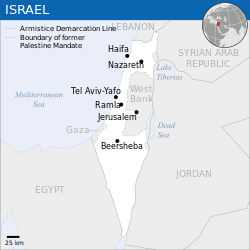
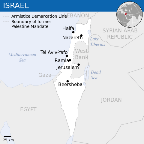
English: Locator map of Israel. العربية: خريطة إسرائيل. |
| Data | |
| Font |
English: [1], OCHA, UNCS |
| Autor | |
| Autras versions |
|
| SVG information | Aqueste imatge vectorial es estat creat amb Inkscape. Cette carte SVG utilise du texte encapsulé qui peut être traduit facilement à l'aide d'un éditeur de texte. |
_-_ISR_-_UNOCHA-ar.svg)
_-_ISR_-_UNOCHA-ur.svg)
_-_ISR_-_UNOCHA-zh.svg)
_-_ISR_-_UNOCHA-id.svg)
_-_ISR_-_UNOCHA.svg?uselang=oc)
Publicat jos licéncia(s)
- Sètz liure :
- de partejar – de copiar, distribuir e transmetre aquesta òbra
- d'adaptar – d'adaptar aquesta òbra
- Jos las condicions seguentas :
- atribucion – Vos cal atribuir aquesta òbra amb lo biais especificat per l'autor o lo concedent (mas pas dins un sens que suggerís que vos apròvan o qu'apròvan l'utilizacion d'aquesta òbra).
 This map is part of a collection of 216 free country maps, created by the UN Office for the Coordination of Humanitarian Affairs (OCHA), to be used in print, web or broadcast products.
The ReliefWeb Location Maps released here are maps that highlight a country, its capital, major populated places and the surrounding regions. Attribution Requirements
Using the map without modifications: ensure that the sources and the disclaimer are below the map. Credit as follows: "Credit: OCHA". For use with alteration: remove the OCHA logo and disclaimer following any modification to the map, but keep the data sources as mentioned below the map. Credit the modified map as follows: "Based on OCHA map". You are responsible for the content of your map. We are keen to receive your feedback and hear how you used OCHA's maps. We would be grateful if you would notify us by e-mail and share your work with us. UN Disclaimer
The designations employed and the presentation of material of this map do not imply the expression of any opinion whatsoever on the part of the Secretariat of the United Nations concerning the legal status of any country, territory, city or area or of its authorities or concerning the delimitation of its frontiers or boundaries. |

|
La informació en text que era visible en la mateixa imatge ha estat traslladada a les metadades del fitxer o a la pàgina de descripció. D'aquesta forma és més fàcil que la imatge es pugui reutilitzar, que no depengui d'una llengua determinada i que el text es pugui processar i cercar més fàcilment. Commons desaconsella posar informació textual en les imatges. Totes les llicències acceptades a Commons permeten aquest tipus de modificació com a obra derivada.
Si la informació d'atribució ha estat esborrada i la imatge no està sota domini públic, substituïu aquesta plantilla per {{Attribution metadata from licensed image}}.
|
Istoric del fichièr
Clicar sus una data e una ora per veire lo fichièr tal coma èra a aqueste moment
| Data e ora | Miniatura | Dimensions | Utilizaire | Comentari | |
|---|---|---|---|---|---|
| actual | 8 octobre de 2023 a 08.26 | | 250×250 (141 Ko) | Trần Nguyễn Minh Huy | File uploaded using svgtranslate tool (https://svgtranslate.toolforge.org/). Added translation for vi. |
| 27 julhet de 2022 a 06.39 |  | 250×250 (140 Ko) | Enkhsaihan2005 | File uploaded using svgtranslate tool (https://svgtranslate.toolforge.org/). Added translation for mn. | |
| 27 julhet de 2022 a 06.38 |  | 250×250 (139 Ko) | Enkhsaihan2005 | File uploaded using svgtranslate tool (https://svgtranslate.toolforge.org/). Added translation for mn. | |
| 28 març de 2022 a 01.48 |  | 250×250 (136 Ko) | Nyilvoskt | File uploaded using svgtranslate tool (https://svgtranslate.toolforge.org/). Added translation for id. | |
| 17 febrièr de 2022 a 15.21 |  | 250×250 (134 Ko) | Kurmanbek | File uploaded using svgtranslate tool (https://svgtranslate.toolforge.org/). Added translation for tr. | |
| 17 febrièr de 2016 a 22.27 |  | 250×250 (130 Ko) | Wereldburger758 | Resized page to drawing. Removal watermark. Validation of image. | |
| 19 agost de 2014 a 03.21 |  | 250×250 (185 Ko) | Pharos | == {{int:filedesc}} == {{Information |description={{en|1=Locator map of Chile.}} |date=2013 |source={{en|1=[http://reliefweb.int/map/chile/chile-location-map-2013 Chile Locator Map (ReliefWeb)]}} |author={{en|1=[[w:en:United Nations Offi... |
Paginas que contenon lo fichièr
I a ges de pagina que compòrta un ligam vèrs aqueste imatge.
Usatge global del fichièr
Los autres wikis seguents utilizan aqueste imatge :
- Utilizacion sus ar.wikipedia.org
- Utilizacion sus az.wikipedia.org
- Utilizacion sus ban.wikipedia.org
- Utilizacion sus bcl.wikipedia.org
- Utilizacion sus bh.wikipedia.org
- Utilizacion sus blk.wikipedia.org
- Utilizacion sus bxr.wikipedia.org
- Utilizacion sus dty.wikipedia.org
- Utilizacion sus en.wikipedia.org
- Utilizacion sus es.wikipedia.org
- Utilizacion sus eu.wikipedia.org
- Utilizacion sus fa.wikipedia.org
- Utilizacion sus fr.wikipedia.org
- Utilizacion sus gu.wikipedia.org
- Utilizacion sus hy.wikipedia.org
- Utilizacion sus id.wikipedia.org
- Utilizacion sus incubator.wikimedia.org
- Utilizacion sus ka.wikipedia.org
- Utilizacion sus lo.wikipedia.org
- Utilizacion sus ml.wikipedia.org
- Utilizacion sus mn.wikipedia.org
- Utilizacion sus mzn.wikipedia.org
- Utilizacion sus ne.wikipedia.org
- Utilizacion sus nso.wikipedia.org
- Utilizacion sus pa.wikipedia.org
- Utilizacion sus pnb.wikipedia.org
- Utilizacion sus ro.wikipedia.org
- Utilizacion sus ru.wikipedia.org
- Utilizacion sus sco.wikipedia.org
- Utilizacion sus sd.wikipedia.org
- Utilizacion sus si.wikipedia.org
- Utilizacion sus sl.wikipedia.org
- Utilizacion sus sq.wikipedia.org
- Utilizacion sus su.wikipedia.org
- Utilizacion sus tcy.wikipedia.org
- Utilizacion sus te.wikipedia.org
- Utilizacion sus th.wikipedia.org
- Utilizacion sus to.wikipedia.org
- Utilizacion sus tr.wikipedia.org
Veire l'utilizacion globala d'aqueste fichièr.
_-_ISR_-_UNOCHA.svg)
_-_ISR_-_UNOCHA.svg)