
Fichièr:South Island.jpg

Fichièr d'origina (2 618 × 2 926 pixèl, talha del fichièr: 1,26 Mo, tipe MIME: image/jpeg)
| Aqueste fichièr proven de Wikimedia Commons?. Las informacions que lo concernisson son afichadas çaijós (procedura). |
Descripcion
| Descripcion |
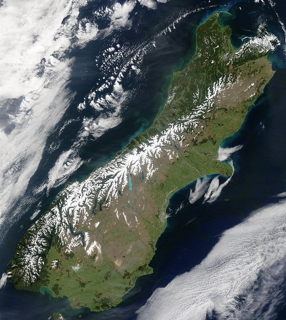
English: This true-color image provides a nearly cloud-free look at the South Island of New Zealand, from NASA’s Terra satellite.
Українська: Сніг виділяє гірські хребти Південних Альп (супутниковий знімок НАСА), Нова Зеландія. |
| Data | |
| Font | NASA's Earth Observatory |
| Autor | Jacques Descloitres, MODIS Land Rapid Response Team at NASA GSFC |
| Permission (Reütilizacion d'aqueste fichièr) |
Public domain - original work of NASA |
| Autras versions | Image:South.island.arp.750pix.jpg is lower resolution, more tightly cropped |
This true-color image provides a nearly cloud-free look at the South Island of New Zealand. The scene was acquired by NASA’s Terra satellite, on October 23, 2002.
Forested areas are clearly indicated by the very dark green, particularly in the northwest and southwest. The braided Waimakariri and Rakaia rivers can also clearly be seen as they make their way to the east coast on either side of Banks Peninsula.
Image courtesy Jacques Descloitres, MODIS Land Rapid Response Team at NASA GSFC.
SOURCE: http://earthobservatory.nasa.gov/Newsroom/NewImages/images.php3?img_id=10881
”The purpose of NASA's Earth Observatory is to provide a freely-accessible publication on the Internet where the public can obtain new satellite imagery and scientific information about our home planet. The focus is on Earth's climate and environmental change. In particular, we hope our site is useful to public media and educators. Any and all materials published on the Earth Observatory are freely available for re-publication or re-use, except where copyright is indicated. We ask that NASA's Earth Observatory be given credit for its original materials.”
Publicat jos licéncia(s)
| Aquest fitxer és en el domini públic perquè ha estat creat per la NASA. L'avís legal de la NASA diu que «el material de la NASA no està protegit per copyright si no es diu el contrari». (NASA copyright policy page o JPL Image Use Policy). | ||
 |
Atenció:
|
Istoric del fichièr
Clicar sus una data e una ora per veire lo fichièr tal coma èra a aqueste moment
| Data e ora | Miniatura | Dimensions | Utilizaire | Comentari | |
|---|---|---|---|---|---|
| actual | 18 mai de 2006 a 00.48 | | 2 618×2 926 (1,26 Mo) | Avenue | {{Information| |Description=This true-color image provides a nearly cloud-free look at the South Island of New Zealand, from NASA’s Terra satellite. |Source=[http://earthobservatory.nasa.gov/Newsroom/NewImages/images.php3?img_id=10881 NASA's Earth Obser |
Paginas que contenon lo fichièr
La pagina çaijós compòrta aqueste imatge :
Usatge global del fichièr
Los autres wikis seguents utilizan aqueste imatge :
- Utilizacion sus af.wikipedia.org
- Utilizacion sus ang.wikipedia.org
- Utilizacion sus an.wikipedia.org
- Utilizacion sus ar.wikipedia.org
- Utilizacion sus bh.wikipedia.org
- Utilizacion sus ceb.wikipedia.org
- Utilizacion sus cs.wikipedia.org
- Utilizacion sus da.wikipedia.org
- Utilizacion sus de.wikipedia.org
- Utilizacion sus de.wikivoyage.org
- Utilizacion sus el.wikipedia.org
- Utilizacion sus en.wikipedia.org
- Utilizacion sus en.wikiversity.org
- Utilizacion sus eo.wikipedia.org
- Utilizacion sus et.wikipedia.org
- Utilizacion sus fa.wikipedia.org
- Utilizacion sus fi.wikipedia.org
- Utilizacion sus fr.wikipedia.org
- Utilizacion sus gl.wikipedia.org
- Utilizacion sus he.wikipedia.org
- Utilizacion sus hi.wikipedia.org
- Utilizacion sus hr.wikipedia.org
- Utilizacion sus hu.wikipedia.org
- Utilizacion sus is.wikipedia.org
- Utilizacion sus it.wikipedia.org
- Utilizacion sus ja.wikipedia.org
- Utilizacion sus mi.wikipedia.org
- Utilizacion sus mk.wikipedia.org
- Utilizacion sus ml.wikipedia.org
- Utilizacion sus mn.wikipedia.org
- Utilizacion sus nl.wikipedia.org
- Utilizacion sus nn.wikipedia.org
- Utilizacion sus no.wikipedia.org
- Utilizacion sus pnb.wikipedia.org
- Utilizacion sus pt.wikipedia.org
- Utilizacion sus sh.wikipedia.org
- Utilizacion sus sk.wikipedia.org
- Utilizacion sus sl.wikipedia.org
- Utilizacion sus sr.wikipedia.org
- Utilizacion sus sv.wikipedia.org
- Utilizacion sus tpi.wikipedia.org
- Utilizacion sus tr.wikipedia.org
- Utilizacion sus zh-min-nan.wikipedia.org
Veire l'utilizacion globala d'aqueste fichièr.