
Fichièr:Location Tumen-River.png
Pas de resolucion mai nauta de disponibla.
Location_Tumen-River.png (489 × 337 pixèl, talha del fichièr: 111 Ko, tipe MIME: image/png)
| Aqueste fichièr proven de Wikimedia Commons?. Las informacions que lo concernisson son afichadas çaijós (procedura). |
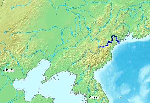
English: The Tumen River is a long river that serves as part of the boundary between China, North Korea, and the Russian Federation.
- Русский: ru:Туманная (река) - река на Дальнем Востоке, по которой проходят границы России, КНДР и Китая.
This image is in the public domain because it came from the site https://www.demis.nl/products/web-map-server/examples/ and was released by the copyright holder. Permission is granted to copy, distribute and/or modify this map since it is based on free of copyright images from: www.demis.nl. See also approval email on de.wp and its clarification.
|
| This work has been released into the public domain by its copyright holder, www.demis.nl. This applies worldwide. En alguns països això pot no ser legalment possible, en tal cas: www.demis.nl concedeix a tothom el dret d'usar aquesta obra per a qualsevol propòsit, sense cap condició llevat d'aquelles requerides per la llei.
|
Istoric del fichièr
Clicar sus una data e una ora per veire lo fichièr tal coma èra a aqueste moment
| Data e ora | Miniatura | Dimensions | Utilizaire | Comentari | |
|---|---|---|---|---|---|
| actual | 13 genièr de 2007 a 15.16 | | 489×337 (111 Ko) | Kaba | en:Tumen River is a long river that serves as part of the boundary between en:China, en:North Korea, and the [:en:Russian Federation|]]. ja:豆満江はは中朝国境のja:白頭山に源流を発し、ja:中国、[[:ja |
Paginas que contenon lo fichièr
La pagina çaijós compòrta aqueste imatge :
Usatge global del fichièr
Los autres wikis seguents utilizan aqueste imatge :
- Utilizacion sus af.wikipedia.org
- Utilizacion sus ar.wikipedia.org
- Utilizacion sus azb.wikipedia.org
- Utilizacion sus bn.wikipedia.org
- Utilizacion sus br.wikipedia.org
- Utilizacion sus ckb.wikipedia.org
- Utilizacion sus cs.wikipedia.org
- Utilizacion sus de.wikipedia.org
- Utilizacion sus en.wikipedia.org
- Utilizacion sus en.wikinews.org
- Utilizacion sus es.wikipedia.org
- Utilizacion sus fa.wikipedia.org
- Utilizacion sus fi.wikipedia.org
- Utilizacion sus fi.wikinews.org
- Utilizacion sus fr.wikipedia.org
- Utilizacion sus he.wikipedia.org
- Utilizacion sus hi.wikipedia.org
- Utilizacion sus hu.wikipedia.org
- Utilizacion sus id.wikipedia.org
- Utilizacion sus it.wikipedia.org
- Utilizacion sus ja.wikipedia.org
- Utilizacion sus jv.wikipedia.org
- Utilizacion sus ko.wikipedia.org
- Utilizacion sus mk.wikipedia.org
- Utilizacion sus ml.wikipedia.org
- Utilizacion sus mn.wikipedia.org
- Utilizacion sus nl.wikipedia.org
- Utilizacion sus nn.wikipedia.org
- Utilizacion sus no.wikipedia.org
- Utilizacion sus pa.wikipedia.org
- Utilizacion sus pl.wikipedia.org
- Utilizacion sus pnb.wikipedia.org
- Utilizacion sus pt.wikipedia.org
- Utilizacion sus ru.wikipedia.org
- Utilizacion sus sh.wikipedia.org
- Utilizacion sus sv.wikipedia.org
- Utilizacion sus th.wikipedia.org
- Utilizacion sus vi.wikipedia.org
- Utilizacion sus zh-min-nan.wikipedia.org
- Utilizacion sus zh-yue.wikipedia.org
Veire l'utilizacion globala d'aqueste fichièr.