
Fichièr:Karte saarbruecken in deutschland.png
Pas de resolucion mai nauta de disponibla.
Karte_saarbruecken_in_deutschland.png (188 × 235 pixèl, talha del fichièr: 5 Ko, tipe MIME: image/png)
| Aqueste fichièr proven de Wikimedia Commons?. Las informacions que lo concernisson son afichadas çaijós (procedura). |
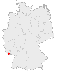
Descripcion
English: Location of Saabruecken in Germany
Lëtzebuergesch: Lag vu Saarbrécken an Däitschland
Zusammenfassung
Lage von Saarbrücken in Deutschland
Publicat jos licéncia(s)
This image was generated with OpenGeoDB. The information there is placed in the public domain, images generated from OpenGeoDB are derivative works without passing the threshold of creativity, they are therefore also public domain.
| Aquesta imatge no és apta per tenir drets d'autor perquè consta totalment d'informació que és propietat comuna i no conté cap creació original. Per tant, és en el domini públic. |
Istoric del fichièr
Clicar sus una data e una ora per veire lo fichièr tal coma èra a aqueste moment
| Data e ora | Miniatura | Dimensions | Utilizaire | Comentari | |
|---|---|---|---|---|---|
| actual | 25 junh de 2006 a 16.18 | | 188×235 (5 Ko) | Yassen~commonswiki | english:Location of Saabrucken in Germany<br> deutsch:Lage von Saarbrücken in Deutschland<br> {{GFDL-OpenGeoDB}} Category:Locator_maps_of_cities_in_Germany |
Paginas que contenon lo fichièr
I a ges de pagina que compòrta un ligam vèrs aqueste imatge.
Usatge global del fichièr
Los autres wikis seguents utilizan aqueste imatge :
- Utilizacion sus af.wikipedia.org
- Utilizacion sus azb.wikipedia.org
- Utilizacion sus de.wikipedia.org
- Utilizacion sus de.wikinews.org
- Utilizacion sus fa.wikipedia.org
- Utilizacion sus fy.wikipedia.org
- Utilizacion sus io.wikipedia.org
- Utilizacion sus is.wikipedia.org
- Utilizacion sus ja.wikipedia.org
- Utilizacion sus la.wiktionary.org
- Utilizacion sus lmo.wikipedia.org
- Utilizacion sus pl.wikivoyage.org
- Utilizacion sus pms.wikipedia.org
- Utilizacion sus pnb.wikipedia.org
- Utilizacion sus ps.wikipedia.org
- Utilizacion sus sq.wikipedia.org
- Utilizacion sus uk.wikipedia.org
- Utilizacion sus zh-yue.wikipedia.org