
Fichièr:California State Route 84.svg

Talha d'aquesta previsualizacion PNG per aquest fichièr SVG: 800 × 444 pixèls. Autras resolucions : 320 × 178 pixèls | 640 × 356 pixèls | 1 024 × 569 pixèls | 1 280 × 711 pixèls | 2 560 × 1 422 pixèls | 1 152 × 640 pixèls.
Fichièr d'origina (Fichièr SVG, resolucion de 1 152 × 640 pixèls, talha : 479 Ko)
| Aqueste fichièr proven de Wikimedia Commons?. Las informacions que lo concernisson son afichadas çaijós (procedura). |
Descripcion
| Descripcion |
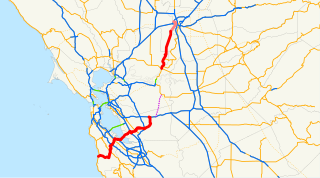
English: This is a map of State Route 84 in California, with recently-relinquished parts in pink and unconstructed parts in purple. |
| Font | Email me if you would like a copy of the GIS data I created for the highways. |
| Autor | User:NE2 |
Sources: BTS North American Transportation Atlas Data copie d'archive at the Wayback Machine, Caltrans State Truck Route List (XLS file), Caltrans Log of Bridges on State Highways, All Caltrans Traffic Volumes on CSHS, California State Legislature Definitions of Routes
Publicat jos licéncia(s)
| Jo, el titular del copyright d'aquesta obra, l'allibero al domini públic. Això s'aplica a tot el món. En alguns països això pot no ser legalment possible, en tal cas: Jo faig concessió a tothom del dret d'usar aquesta obra per a qualsevol propòsit, sense cap condició llevat d'aquelles requerides per la llei. |
Istoric del fichièr
Clicar sus una data e una ora per veire lo fichièr tal coma èra a aqueste moment
| Data e ora | Miniatura | Dimensions | Utilizaire | Comentari | |
|---|---|---|---|---|---|
| actual | 19 decembre de 2007 a 16.18 | | 1 152×640 (479 Ko) | NE2 | Oops. |
| 19 decembre de 2007 a 16.17 |  | 1 152×640 (395 Ko) | NE2 | == Summary == This is a map of State Route 85 in California. Email me if you would like a copy of the GIS data I created for the highways. Category:California State Route 85 [[Category:Maps of state highways in California|08 | |
| 19 decembre de 2007 a 16.16 |  | 1 152×640 (479 Ko) | NE2 | == Summary == This is a map of State Route 84 in California, with recently-relinquished parts in pink and unconstructed parts in purple. Email me if you would like a copy of the GIS data I created for the highways. [[Category:Ca |
Paginas que contenon lo fichièr
La pagina çaijós compòrta aqueste imatge :
Usatge global del fichièr
Los autres wikis seguents utilizan aqueste imatge :
- Utilizacion sus es.wikipedia.org
- Utilizacion sus fi.wikipedia.org
- Utilizacion sus www.wikidata.org
- Utilizacion sus zh-min-nan.wikipedia.org
- Utilizacion sus zh.wikipedia.org