
Fichièr:Tidal Bore - geograph.org.uk - 324581.jpg
Pas de resolucion mai nauta de disponibla.
Tidal_Bore_-_geograph.org.uk_-_324581.jpg (640 × 461 pixèl, talha del fichièr: 77 Ko, tipe MIME: image/jpeg)
| Aqueste fichièr proven de Wikimedia Commons?. Las informacions que lo concernisson son afichadas çaijós (procedura). |
Descripcion
| Descripcion |
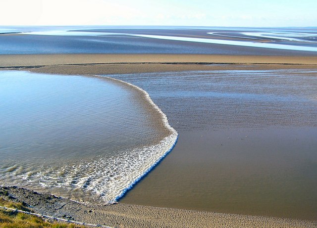
English: Tidal Bore The channels are constantly changing and consequently not shown on the OS map. Here the tidal bore is coming up a channel, one of several such channels in the estuary, on its way to Arnside some 8km away as the tide flows. It took 2 hours and 5 minutes to reach the viaduct at Arnside (shown in 324585) from this point. |
| Data | |
| Font | From geograph.org.uk |
| Autor | Arnold Price |
| Atribucion (imposé par la licence) | Arnold Price / Tidal Bore / |
| Posició de l'objecte | | Aquesta i altres imatges properes a: OpenStreetMap |
|---|
_heading:202.00&language=oc)
Publicat jos licéncia(s)

|
Aquesta imatge prové de la col·lecció del projecte Geograph British Isles. Vegeu la pàgina d'aquesta fotografia al lloc web Geograph per a més informació del fotògraf. El titular dels drets d'autor d'aquesta imatge és Arnold Price i autoritza utilitzar-la sota la llicència Reconeixement-CompartirIgual 2.0 de Creative Commons.
|
Aqueste fichièr es jos licéncia Creative Commons licéncia generica atribucion-partiment a l'identic 2.0
Atribucion: Arnold Price
- Sètz liure :
- de partejar – de copiar, distribuir e transmetre aquesta òbra
- d'adaptar – d'adaptar aquesta òbra
- Jos las condicions seguentas :
- atribucion – Vos cal atribuir aquesta òbra amb lo biais especificat per l'autor o lo concedent (mas pas dins un sens que suggerís que vos apròvan o qu'apròvan l'utilizacion d'aquesta òbra).
- partiment a l'identic – Se modificatz, transformatz, o vos basatz sus aquesta òbra, vos cal distribuir l'òbra resultanta jos la meteissa licéncia o una licéncia similara a aquesta.
Istoric del fichièr
Clicar sus una data e una ora per veire lo fichièr tal coma èra a aqueste moment
| Data e ora | Miniatura | Dimensions | Utilizaire | Comentari | |
|---|---|---|---|---|---|
| actual | 30 decembre de 2010 a 19.45 | | 640×461 (77 Ko) | GeographBot | == {{int:filedesc}} == {{Information |description={{en|1=Tidal Bore The channels are constantly changing and consequently not shown on the OS map. Here the tidal bore is coming up a channel, one of several such channels in the estuary, on its way to Arnsi |
Paginas que contenon lo fichièr
La pagina çaijós compòrta aqueste imatge :
Usatge global del fichièr
Los autres wikis seguents utilizan aqueste imatge :
- Utilizacion sus ar.wikipedia.org
- Utilizacion sus bn.wikipedia.org
- Utilizacion sus en.wikipedia.org
- Utilizacion sus es.wikipedia.org
- Utilizacion sus fa.wikipedia.org
- Utilizacion sus fr.wikipedia.org
- Utilizacion sus fr.wikiversity.org
- Utilizacion sus ga.wikipedia.org
- Utilizacion sus he.wikipedia.org
- Utilizacion sus ms.wikipedia.org
- Utilizacion sus ro.wikipedia.org
- Utilizacion sus sl.wikipedia.org
- Utilizacion sus tr.wikipedia.org
- Utilizacion sus uk.wikipedia.org
- Utilizacion sus zh-yue.wikipedia.org