
Fichièr:Seas of the Philippines.svg

Fichièr d'origina (Fichièr SVG, resolucion de 2 106 × 3 971 pixèls, talha : 517 Ko)
| Aqueste fichièr proven de Wikimedia Commons?. Las informacions que lo concernisson son afichadas çaijós (procedura). |
Descripcion
| Descripcion |
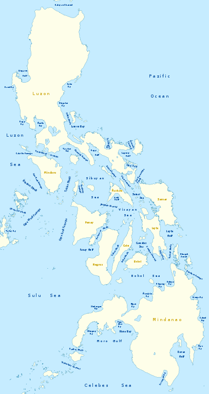
Deutsch: Karte der Seegewässer der Philippinen
English: Map of seas of the Philippines |
|
| Data | ||
| Font | Trabalh personal, using United States National Imagery and Mapping Agency data | |
| Autor | NordNordWest | |
| Permission (Reütilizacion d'aqueste fichièr) |
Aquest fitxer està publicat sota la llicència de Creative Commons Reconeixement i Compartir Igual 3.0 Alemanya.
 Aqueste fichièr es jos licéncia Creative Commons licéncia generica atribucion-partiment a l'identic 3.0
|
|
| Autras versions |
|


|
Cette carte a été créée ou améliorée dans le Kartenwerkstatt (Atelier cartographique allemand). Vous pouvez également y proposer des cartes à améliorer.
|
Istoric del fichièr
Clicar sus una data e una ora per veire lo fichièr tal coma èra a aqueste moment
| Data e ora | Miniatura | Dimensions | Utilizaire | Comentari | |
|---|---|---|---|---|---|
| actual | 14 febrièr de 2011 a 21.25 | | 2 106×3 971 (517 Ko) | NordNordWest | == {{int:filedesc}} == {{Information |Description= {{de|Karte der Seegewässer der Philippinen}} {{en|Map of seas of the Philippines}} |Source={{Own}}, using United States National Imagery and Mapping Agency data |Date=2012-02-14 |Author={{U|NordNordWest |
Paginas que contenon lo fichièr
I a ges de pagina que compòrta un ligam vèrs aqueste imatge.
Usatge global del fichièr
Los autres wikis seguents utilizan aqueste imatge :
- Utilizacion sus de.wikipedia.org
- Utilizacion sus en.wikipedia.org
- South China Sea
- Luzon Strait
- Leyte Gulf
- Philippine Sea
- Canigao Channel
- Cebu Strait
- Sulu Sea
- Moro Gulf
- Davao Gulf
- Panay Gulf
- Bohol Sea
- Lingayen Gulf
- Surigao Strait
- Celebes Sea
- Sibuyan Sea
- Visayan Sea
- San Juanico Strait
- San Bernardino Strait
- Balintang Channel
- Camotes Sea
- Samar Sea
- Ragay Gulf
- Lagonoy Gulf
- Sorsogon Bay
- Albay Gulf
- Tablas Strait
- Mindoro Strait
- Balabac Strait
- Verde Island Passage
- Sibutu Passage
- Jintotolo Channel
- Tañon Strait
- Dinagat Sound
- Template:List of Philippine seas
- Iloilo Strait
- Guimaras Strait
- Basilan Strait
- Maqueda Channel
- Burias Pass
- Ticao Pass
- Utilizacion sus ilo.wikipedia.org
Veire l'utilizacion globala d'aqueste fichièr.