
Fichièr:Yosemite meadows 2004-09-04.jpg

Fichièr d'origina (2 250 × 1 500 pixèl, talha del fichièr: 1,5 Mo, tipe MIME: image/jpeg)
| Aqueste fichièr proven de Wikimedia Commons?. Las informacions que lo concernisson son afichadas çaijós (procedura). |
| Descripcion |
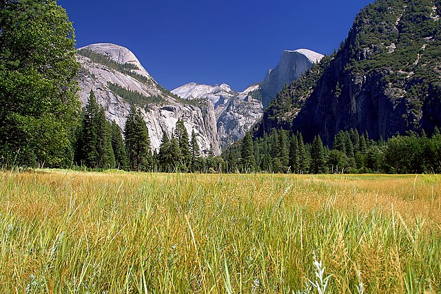
Français : Le Half Dome vu de Yosemite Meadows, les prairies humides qui couvrent le fond de la Vallée de Yosemite, dans le Parc national du même nom, en Californie (États-Unis). |
||||||
| Data | |||||||
| Font | http://pdphoto.org/ (high resolution version of an image similar to [1]) | ||||||
| Autor | Jon Sullivan | ||||||
| Permission (Reütilizacion d'aqueste fichièr) |
|
| Posició de la càmera | | Aquesta i altres imatges properes a: OpenStreetMap |
|---|
This was formerly a featured picture on Wikimedia Commons.
|
Aquesta imatge va ser escollida imatge del dia el 21 March 2005. La seva descripció va ser la següent: English: Yosemite National Park, USA Altres idiomes:
Čeština: Yosemitský národní park, USA Deutsch: Yosemite National Park, USA English: Yosemite National Park, USA Español: Parque Nacional Yosemite, EE.UU. Français : Parc national du Yosemite, USA Italiano: Yosemite National Park, USA Lëtzebuergesch: Yosemite National Park, USA Português: Parque Nacional Yosemite, EUA 中文: 美国约塞米蒂国家公园的沼泽 |
Istoric del fichièr
Clicar sus una data e una ora per veire lo fichièr tal coma èra a aqueste moment
| Data e ora | Miniatura | Dimensions | Utilizaire | Comentari | |
|---|---|---|---|---|---|
| actual | 31 genièr de 2005 a 06.25 | | 2 250×1 500 (1,5 Mo) | MarkSweep | Half Dome in Yosemite National Park {{PD-PDphoto.org}} |
Paginas que contenon lo fichièr
Las paginas çaijós compòrtan aqueste imatge :
Usatge global del fichièr
Los autres wikis seguents utilizan aqueste imatge :
- Utilizacion sus ca.wikipedia.org
- Utilizacion sus de.wikipedia.org
- Utilizacion sus fi.wikipedia.org
- Utilizacion sus fr.wikipedia.org
- Utilizacion sus hu.wikipedia.org
- Utilizacion sus ia.wikipedia.org
- Utilizacion sus it.wikipedia.org
- Utilizacion sus ja.wikipedia.org
- Utilizacion sus ko.wikipedia.org
- Utilizacion sus krc.wikipedia.org
- Utilizacion sus mn.wikipedia.org
- Utilizacion sus nl.wikipedia.org
- Utilizacion sus no.wikipedia.org
- Utilizacion sus pl.wikipedia.org
- Utilizacion sus ru.wikipedia.org
- Utilizacion sus ru.wikinews.org
- Utilizacion sus sr.wikipedia.org
- Utilizacion sus uk.wikipedia.org
- Utilizacion sus vi.wikipedia.org
- Utilizacion sus zh.wikipedia.org