Fichièr:WestBengalDistricts numbered.svg

Lo contengut de la pagina non es disponible dins una autra lenga.
Un article de Wikipèdia, l'enciclopèdia liura.

Fichièr d'origina(Fichièr SVG, resolucion de 768 × 1 159 pixèls, talha : 311 Ko)

Descripcion

Descripcion
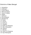
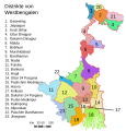
English: Original summary by creator of base svg file deeptrivia. Districts of West Bengal

Based on https://web.archive.org/web/20040606103522/www.censusindia.net/results/2001maps/wbengal01.html

Modifications by Mouryan:

  1. upladed translated version of File:WestBengalDistricts numbered de.svg.
  2. The districts of Dakshin 24 Parganas district and Uttar 24 Parganas were incorrectly numbered in the Map. The errors have been rectified.

Modifications by Furfur:

  1. The 4 (four) new districts of West Bengal namely Paschim Bardhaman district (bifurcated from Bardhaman district), Kalimpong district (bifurcated from Darjeeling district), Alipurduar district (bifurcated from Jalpaiguri district) and Jhargram district (bifurcated from Paschim Medinipur district) has been shown in this new Updated map.

Modifications by Antorjal:

  1. Midnapore District has been bifurcated to show both Paschim Medinipur and Purba Medinipur.
  2. Numbered and listed districts per comments at peer-review.
  3. Font size reduced for clarity, since the districts are now listed.
  4. Many of the spellings did not conform to linked articles in the text. All spellings now match the West Bengal article spellings.
Data 8 octobre de 2006 (date de téléversement originale)
Font Transféré de en.wikipedia à Commons par Padawane.
Autor Original téléversé par Antorjal de Wikipèdia en anglés.
Autras versions

[modificar]

SVG information
InfoField
 
El codi font d’aquest SVG no és vàlid perquè hi ha un error.
 
Aqueste imatge vectorial es estat creat amb Adobe Illustrator,
 
et avec Inkscape.
 
 Cette carte SVG utilise du texte encapsulé qui peut être traduit facilement à l'aide d'un éditeur de texte.

Publicat jos licéncia(s)

w:oc:Creative Commons
atribucion partiment a l'identic
Aquest fitxer està llicenciat sota les llicències de Creative Commons Reconeixement - CompartirIgual 2.5 Genèrica, 2.0 Genèrica i 1.0 Genèrica.
Sètz liure :
  • de partejar – de copiar, distribuir e transmetre aquesta òbra
  • d'adaptar – d'adaptar aquesta òbra
Jos las condicions seguentas :
  • atribucion – Vos cal atribuir aquesta òbra amb lo biais especificat per l'autor o lo concedent (mas pas dins un sens que suggerís que vos apròvan o qu'apròvan l'utilizacion d'aquesta òbra).
  • partiment a l'identic – Se modificatz, transformatz, o vos basatz sus aquesta òbra, vos cal distribuir l'òbra resultanta jos la meteissa licéncia o una licéncia similara a aquesta.
w:oc:Creative Commons
atribucion partiment a l'identic
Aqueste fichièr es jos licéncia Creative Commons licéncia generica atribucion-partiment a l'identic 3.0 Subjecte a l'avís legal.
Sètz liure :
  • de partejar – de copiar, distribuir e transmetre aquesta òbra
  • d'adaptar – d'adaptar aquesta òbra
Jos las condicions seguentas :
  • atribucion – Vos cal atribuir aquesta òbra amb lo biais especificat per l'autor o lo concedent (mas pas dins un sens que suggerís que vos apròvan o qu'apròvan l'utilizacion d'aquesta òbra).
  • partiment a l'identic – Se modificatz, transformatz, o vos basatz sus aquesta òbra, vos cal distribuir l'òbra resultanta jos la meteissa licéncia o una licéncia similara a aquesta.
Aquest avís de llicència s'ha afegit a aquest fitxer d'acord amb l'actualització de la llicència GFDL.
GNU head Avètz la permission de copiar, distribuir e modificar aqueste document segon los tèrmes de la Licéncia de documentacion liura GNU, version 1.2 o mai recenta publicada per la Free Software Foundation; sens seccions inalterablas, sens tèxte de primièra pagina de tempa e sens tèxte de darrièra pagina de tempa. Un exemplar de la licéncia es inclús dins la seccion intitulada GNU Free Documentation License. Subjecte a l'avís legal.

Registre original de càrregues

La pàgina de descripció original era aquí. Els noms d'usuari a continuació es refereixen a en.wikipedia.
  • 2006-12-25 04:28 Deeptrivia 450×500×0 (102714 bytes) Repair attempt
  • 2006-12-25 04:17 Deeptrivia 450×500×0 (101044 bytes) Repair attempt
  • 2006-10-08 14:21 Antorjal 450×500×0 (100501 bytes) Original summary by creator of base svg file [[User:deeptrivia|deeptrivia]]. Districts of West Bengal Based on http://web.archive.org/web/20040606103522/www.censusindia.net/results/2001maps/wbengal01.html Modifications by [[User:Antorjal|An
  • 2006-10-08 14:17 Antorjal 450×500×0 (100294 bytes) Original summary by creator of base svg file [[User:deeptrivia|deeptrivia]]. Districts of West Bengal Based on http://web.archive.org/web/20040606103522/www.censusindia.net/results/2001maps/wbengal01.html Modifications by [[User:Antorjal|An
  • 2006-10-08 14:15 Antorjal 450×500×0 (100501 bytes) Original summary by creator of base svg file [[User:deeptrivia|deeptrivia]]. Districts of West Bengal Based on http://web.archive.org/web/20040606103522/www.censusindia.net/results/2001maps/wbengal01.html Modifications by [[User:Antorjal|An
  • 2006-10-08 14:09 Antorjal 450×500×0 (100484 bytes) Original summary by creator of base svg file [[User:deeptrivia|deeptrivia]]. Districts of West Bengal Based on http://web.archive.org/web/20040606103522/www.censusindia.net/results/2001maps/wbengal01.html Modifications by [[User:Antorjal|An
  • 2006-10-08 14:05 Antorjal 450×500×0 (100501 bytes) Original summary by creator of base svg file [[User:deeptrivia|deeptrivia]]. Districts of West Bengal Based on http://web.archive.org/web/20040606103522/www.censusindia.net/results/2001maps/wbengal01.html Modifications by [[User:Antorjal|An

Llegendes

Afegeix una explicació d'una línia del que representa aquest fitxer
Map of West Bengal

Elements representats en aquest fitxer

subjècte representat

image/svg+xml

Istoric del fichièr

Clicar sus una data e una ora per veire lo fichièr tal coma èra a aqueste moment

Data e oraMiniaturaDimensionsUtilizaireComentari
actual25 abril de 2020 a 21.04Miniatura per la version del 25 abril de 2020 a 21.04768×1 159 (311 Ko)Debjitpaul10Updated text
25 abril de 2020 a 20.45Miniatura per la version del 25 abril de 2020 a 20.45768×1 159 (113 Ko)Debjitpaul10Uploaded a corrected and transparent version.
5 novembre de 2017 a 06.15Miniatura per la version del 5 novembre de 2017 a 06.15576×601 (144 Ko)Mouryan{{Information |Description={{en|Original summary by creator of base svg file deeptrivia. Districts of West Bengal Based on http://web.archive.org/web/20040606103522/www.censusindia.net/results/2001maps/wbengal01.html Modificati...
5 novembre de 2017 a 02.51Miniatura per la version del 5 novembre de 2017 a 02.51576×601 (144 Ko)Mouryan{{Information |Description={{en|Original summary by creator of base svg file deeptrivia. Districts of West Bengal Based on http://web.archive.org/web/20040606103522/www.censusindia.net/results/2001maps/wbengal01.html Modificati...
25 novembre de 2008 a 13.59Miniatura per la version del 25 novembre de 2008 a 13.591 595×2 256 (212 Ko)GDibyendu{{Information |Description=fixed map (sunderbans), fixed district names |Source=based on locator map:West_Bengal_locator_map.svg |Date=2008-11-25 |Author=GDibyendu |Permission=All |other_versions= }}
24 novembre de 2008 a 20.30Miniatura per la version del 24 novembre de 2008 a 20.30450×500 (100 Ko)GDibyenduReverted to version as of 14:58, 17 January 2008 as some error crept in today's attempted upload
24 novembre de 2008 a 20.14Miniatura per la version del 24 novembre de 2008 a 20.141 595×2 256 (191 Ko)GDibyendu{{Information |Description=Corrected the map (it was not showing sunderbans are properly) |Source=This map is based on locator map of West Bengal (West_Bengal_locator_map.svg) |Date=2008-11-24 |Author=GDibyendu |Permission=All |other_versions= }}
22 novembre de 2008 a 17.43Miniatura per la version del 22 novembre de 2008 a 17.43450×500 (100 Ko)GDibyenduReverted to version as of 14:58, 17 January 2008
22 novembre de 2008 a 17.41Miniatura per la version del 22 novembre de 2008 a 17.41450×500 (7 Ko)GDibyendu{{Information |Description=Rewrote text in image to improve readability |Source=Based on last version |Date=2008-11-22 |Author=GDibyendu |Permission=All |other_versions= }}
17 genièr de 2008 a 14.58Miniatura per la version del 17 genièr de 2008 a 14.58450×500 (100 Ko)File Upload Bot (Magnus Manske) {{BotMoveToCommons|en.wikipedia}} {{Information |Description={{en|Original summary by creator of base svg file deeptrivia. Districts of West Bengal Based on http://web.archive.org/web/20040606103522/www.censusindia.net/results/200

Usatge global del fichièr

Los autres wikis seguents utilizan aqueste imatge :

Veire l'utilizacion globala d'aqueste fichièr.

Metadonadas