
Fichièr:UCERF3 fig01-b.jpg

Talha d'aquesta previsualizacion: 800 × 572 pixèls. Autras resolucions : 320 × 229 pixèls | 640 × 457 pixèls | 1 024 × 732 pixèls | 1 280 × 915 pixèls | 2 088 × 1 492 pixèls.
Fichièr d'origina (2 088 × 1 492 pixèl, talha del fichièr: 727 Ko, tipe MIME: image/jpeg)
| Aqueste fichièr proven de Wikimedia Commons?. Las informacions que lo concernisson son afichadas çaijós (procedura). |
| Descripcion |
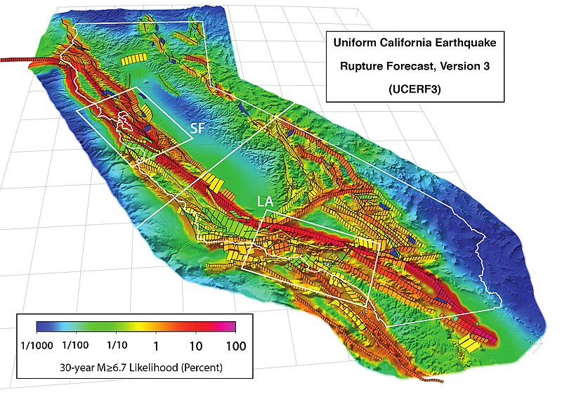
3D perspective view of California (outlined in white) and buffer zone showing the 2,606 fault sections of UCERF 3.1, with white boxes showing the San Francisco Bay (SF) and Los Angeles (LA) areas. Colors show the estimated probability of a section participating in one or more M ≥ 6.7 earthquakes in the 30 years following 2014, accounting for the current level of stress accumulated since the last earthquake. This version's scale uses percentages. Citation: WGCEP (2015-03), “UCERF3: A New Earthquake Forecast for California's Complex Fault System”, in U.S. Geological Survey[1], volume Fact Sheet 2015-3009, DOI:, ISSN 2327-6932 (online). |
|||
| Data | ||||
| Font | http://pubs.usgs.gov/fs/2015/3009/pdf/fs2015-3009.pdf | |||
| Autor | Created by the WGCEP 2014 team, a collaboration of the U.S. Geological Survey, the California Geological Survey, and the Southern California Earthquake Center. | |||
| Permission (Reütilizacion d'aqueste fichièr) |
|
Istoric del fichièr
Clicar sus una data e una ora per veire lo fichièr tal coma èra a aqueste moment
| Data e ora | Miniatura | Dimensions | Utilizaire | Comentari | |
|---|---|---|---|---|---|
| actual | 19 abril de 2016 a 18.59 | | 2 088×1 492 (727 Ko) | J. Johnson | {{Information |Description= 3D perspective view of California (outlined in white) and buffer zone showing the 2,606 fault sections of UCERF 3.1, with white boxes showing the San Francisco Bay (SF) and Los Angeles (LA) areas. Colors show the estimated p... |
Paginas que contenon lo fichièr
La pagina çaijós compòrta aqueste imatge :
Usatge global del fichièr
Los autres wikis seguents utilizan aqueste imatge :
- Utilizacion sus de.wikipedia.org
- Utilizacion sus en.wikipedia.org
- Utilizacion sus ja.wikipedia.org
- Utilizacion sus ko.wikipedia.org
- Utilizacion sus uk.wikipedia.org