
Fichièr:Island of Ireland location map Longford.svg

Talha d'aquesta previsualizacion PNG per aquest fichièr SVG: 481 × 599 pixèls. Autras resolucions : 192 × 240 pixèls | 385 × 480 pixèls | 616 × 768 pixèls | 822 × 1 024 pixèls | 1 643 × 2 048 pixèls | 1 450 × 1 807 pixèls.
Fichièr d'origina (Fichièr SVG, resolucion de 1 450 × 1 807 pixèls, talha : 642 Ko)
| Aqueste fichièr proven de Wikimedia Commons?. Las informacions que lo concernisson son afichadas çaijós (procedura). |
| Descripcion |
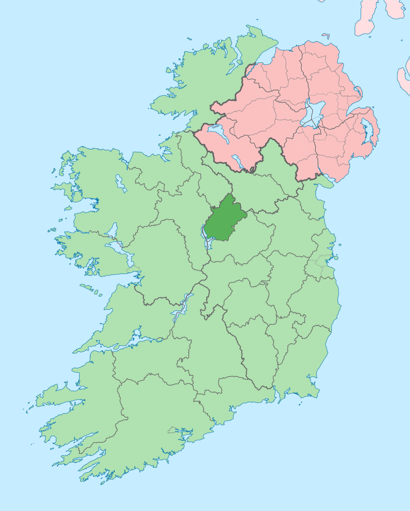
English: The island of Ireland, showing international border between Ireland and Northern Ireland, traditional provinces, traditional counties, and local authority areas in Ireland and Northern Ireland. |
| Data | (UTC) |
| Font | |
| Autor |
|
| Això és una imatge retocada, cosa que vol dir que ha estat alterada digitalment de la seva versió original. Modificacions: Coloured in regions with county of article highlighted. L'original es pot veure a: Island of Ireland location map.svg:
|
Ieu, autor d'aquesta òbra, publiqui jos la licéncia seguenta:
Aqueste fichièr es jos licéncia Creative Commons licéncia generica atribucion-partiment a l'identic 3.0
- Sètz liure :
- de partejar – de copiar, distribuir e transmetre aquesta òbra
- d'adaptar – d'adaptar aquesta òbra
- Jos las condicions seguentas :
- atribucion – Vos cal atribuir aquesta òbra amb lo biais especificat per l'autor o lo concedent (mas pas dins un sens que suggerís que vos apròvan o qu'apròvan l'utilizacion d'aquesta òbra).
- partiment a l'identic – Se modificatz, transformatz, o vos basatz sus aquesta òbra, vos cal distribuir l'òbra resultanta jos la meteissa licéncia o una licéncia similara a aquesta.
Registre original de càrregues
This image is a derivative work of the following images:
- File:Island_of_Ireland_location_map.svg licensed with Cc-by-sa-3.0
- 2010-03-06T20:43:33Z Rannpháirtí anaithnid 1450x1807 (679207 Bytes) Fix incorrectly coloured isands.
- 2010-03-03T22:19:29Z Rannpháirtí anaithnid 1450x1807 (679744 Bytes) {{Information |Description={{de|Positionskarte von [[:de:Irland|Irland]]}} Quadratische Plattkarte, N-S-Streckung 170 %. Geographische Begrenzung der Karte: * N: 55.6° N * S: 51.2° N * W: 11.0° W * O: 5.0° W {{en|Location
Téléversé avec derivativeFX
Istoric del fichièr
Clicar sus una data e una ora per veire lo fichièr tal coma èra a aqueste moment
| Data e ora | Miniatura | Dimensions | Utilizaire | Comentari | |
|---|---|---|---|---|---|
| actual | 3 julhet de 2020 a 09.13 | | 1 450×1 807 (642 Ko) | Chipmunkdavis | Per the Local Government Reform Act 2014, joining both Tipperarys and both Waterfords (and removing Limerick City code). Colouring in islands, cleaning up and grouping code to remove stray objects and show Galway and Lough Ree. |
| 19 julhet de 2010 a 00.54 |  | 1 450×1 807 (815 Ko) | Mabuska | {{Information |Description={{en|The island of Ireland, showing international border between Northern Ireland and Republic of Ireland, traditional provinces, traditional counties, and local authority areas in the Republic of Ireland and Northern Ireland.}} |
Paginas que contenon lo fichièr
La pagina çaijós compòrta aqueste imatge :
Usatge global del fichièr
Los autres wikis seguents utilizan aqueste imatge :
- Utilizacion sus ar.wikipedia.org
- Utilizacion sus ast.wikipedia.org
- Utilizacion sus bg.wikipedia.org
- Utilizacion sus ca.wikipedia.org
- Utilizacion sus ceb.wikipedia.org
- Utilizacion sus cs.wikipedia.org
- Utilizacion sus da.wikipedia.org
- Utilizacion sus en.wikipedia.org
- County Longford
- List of Ireland-related topics
- Ballymahon
- Longford
- Edgeworthstown
- Granard
- Abbeylara
- Mullinalaghta
- Ardagh, County Longford
- Ballinamuck
- Abbeyshrule
- Killoe
- Moydow
- Lanesborough–Ballyleague
- Newtowncashel
- Killashee, County Longford
- Cloondara
- Drumlish
- Taghshinny
- Colehill, County Longford
- Template:Longford-geo-stub
- Keenagh
- Newtown Forbes
- Forgney
- Lisryan
- Brickeens, County Longford
- Template:County Longford
- Cloontaghmore
- Wikipedia:Graphics Lab/Map workshop/Archive/Oct 2014
- Ardagh (barony)
- Granard (barony)
- Longford (County Longford barony)
- Moydow (barony)
- Rathcline
- Shrule (barony)
- Noughaval (civil parish)
- Lough Forbes
Veire l'utilizacion globala d'aqueste fichièr.