Fichièr:Hawaje.jpg

Lo contengut de la pagina non es disponible dins una autra lenga.
Un article de Wikipèdia, l'enciclopèdia liura.

Fichièr d'origina(3 600 × 2 800 pixèl, talha del fichièr: 1,16 Mo, tipe MIME: image/jpeg)

Descripcion

Descripcion
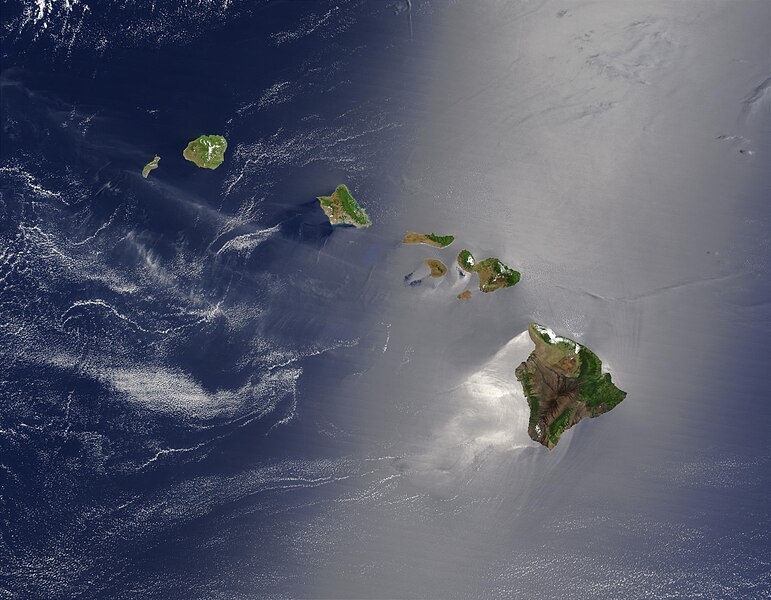
English: Satellite view of Hawaii archipellago (USA).

Original description from NASA:

"A silver swath of sunglint surrounds half of the Hawaiian islands in this true-color Terra MODIS image acquired on May 27, 2003. Sunglint reveals turbulence in the surface waters of the Pacific Ocean. If the surface of the water was as smooth as a perfect mirror, we would see the circle of the Sun as a perfect reflection. But because the surface of the water is ruffled with waves, each wave acts like a mirror and the Sun’s reflection gets softened into a broader silver swath, called the sunglint region.

"In this scene, the winds ruffling the water surface around the Hawaiian Islands create varying patterns, leaving some areas calmer than others. Southwest of Hawaii and Maui, on their leeward sides, calmer waters are indicated by brighter silver coloration. Conversely, notice how most of the vegetation on the Hawaiian Islands grows on their northeastern, or windward, sides.

"From lower right to upper left, the “Big Island” (Hawaii), Maui, Kahoolawe, Lanai, Molokai, Oahu, Kauai, and Niihau islands all make up the state of Hawaii, which lies more than 2,000 miles from any other part of the United States. The small red dot on the Big Island’s southeastern side marks a hot spot on Kilauea Volcano’s southern flank. Kilauea has been erupting almost continuously since January 1983, and is one of the world’s best studied volcanoes."
Français : Vue satellite de l'archipel d'Hawaï (États-Unis).
Data
Font NASA. Image courtesy Jacques Descloitres, MODIS Land Rapid Response Team at NASA GSFC. (IotD Date: 2003-06-03. IotD ID: 15304)
Autor Jacques Descloitres
Autras versions
Modified version
Això és una imatge retocada, cosa que vol dir que ha estat alterada digitalment de la seva versió original. Modificacions: cloned out and healed little red line on the big island. L'original es pot veure a: Hawaje.jpg. Modificacions fetes per IdLoveOne.

Derivative works

Œuvres dérivées de ce fichier :  Hawaje-NoRedLine.jpg

Publicat jos licéncia(s)

Public domain Aquest fitxer és en el domini públic perquè ha estat creat per la NASA. L'avís legal de la NASA diu que «el material de la NASA no està protegit per copyright si no es diu el contrari». (NASA copyright policy page o JPL Image Use Policy).
Atenció:
  • L'ús dels logotips de la NASA, insígnies i emblemes està restringit la llei dels EUA 14 CFR 1221.
  • El lloc web de la NASA disposa d'un gran nombre d'imatges de l'Agència Espacial Russa, o soviètica, i d'altres agències no nord-americanes. Aquestes imatges no són necessàriament en el domini públic.
  • El material del Telescopi espacial Hubble pot tenir els drets reservats si no prové explícitament del STScI. [1]
  • Tot el material de la sonda SOHO està reservat i requereix d'autorització per a un ús comercial no educatiu. [2]
  • Les imatges destacades en el lloc web Astronomy Picture of the Day (APOD) poden tenir drets d'autor. [3]

Llegendes

Afegeix una explicació d'una línia del que representa aquest fitxer

Elements representats en aquest fitxer

subjècte representat

Istoric del fichièr

Clicar sus una data e una ora per veire lo fichièr tal coma èra a aqueste moment

Data e oraMiniaturaDimensionsUtilizaireComentari
actual26 octobre de 2005 a 18.19Miniatura per la version del 26 octobre de 2005 a 18.193 600×2 800 (1,16 Mo)PalladinusHawaii Islands

La pagina çaijós compòrta aqueste imatge :

Usatge global del fichièr

Los autres wikis seguents utilizan aqueste imatge :

Metadonadas