
Fichièr:East Germany 1956-1990.svg

Talha d'aquesta previsualizacion PNG per aquest fichièr SVG: 450 × 456 pixèls. Autras resolucions : 237 × 240 pixèls | 474 × 480 pixèls | 758 × 768 pixèls | 1 011 × 1 024 pixèls | 2 021 × 2 048 pixèls.
Fichièr d'origina (Fichièr SVG, resolucion de 450 × 456 pixèls, talha : 474 Ko)
| Aqueste fichièr proven de Wikimedia Commons?. Las informacions que lo concernisson son afichadas çaijós (procedura). |
Descripcion


.svg)
.svg)
.svg)
.svg)
.svg)


.svg)
.svg)
.svg)


.png)
.png)


.svg)


.svg)

.svg)


.svg)
.svg)
.svg)
.svg)


.svg)
.png)


.svg)


.svg)
.svg)


.svg)


.svg)


.svg)
.svg)
.svg)
.svg)
.svg)
.svg)
.svg)
_cropped.svg)
.svg)
.svg)
.svg)
.svg)
.svg)
.svg)
.svg)
.svg)
.svg)
.svg)
.svg)
.svg)
.svg)
.svg)
.svg)
.svg)
.svg)
.svg)
.svg)
.svg)
.svg)
.svg)
.svg)
.svg)
.svg)
.svg)
.svg)
.svg)
.svg)
.svg)
.svg)
.svg)
.svg)
.svg)
.svg)
.svg)
.svg)
.svg)
.svg)
.svg)
.svg)
.svg)
.svg)
.svg)
.svg)
| Això és una imatge retocada, cosa que vol dir que ha estat alterada digitalment de la seva versió original. Modificacions: {{{1}}}. L'original es pot veure a: Blank map of Europe 1956-1990.svg:
|
Publicat jos licéncia(s)
Ieu, autor d'aquesta òbra, publiqui jos la licéncia seguenta:
Aqueste fichièr es jos licéncia Creative Commons licéncia generica atribucion-partiment a l'identic 3.0
- Sètz liure :
- de partejar – de copiar, distribuir e transmetre aquesta òbra
- d'adaptar – d'adaptar aquesta òbra
- Jos las condicions seguentas :
- atribucion – Vos cal atribuir aquesta òbra amb lo biais especificat per l'autor o lo concedent (mas pas dins un sens que suggerís que vos apròvan o qu'apròvan l'utilizacion d'aquesta òbra).
- partiment a l'identic – Se modificatz, transformatz, o vos basatz sus aquesta òbra, vos cal distribuir l'òbra resultanta jos la meteissa licéncia o una licéncia similara a aquesta.
Registre original de càrregues
This image is a derivative work of the following images:
- File:Blank_map_of_Europe_1956-1990.svg licensed with Cc-by-sa-3.0
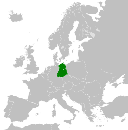
- 2011-10-30T04:43:42Z Alphathon 450x456 (485146 Bytes) == {{int:filedesc}} == {{Information |Description={{en|Blank map of Europe showing national borders as they stood from 1956-1990.}} |Source=*[[:File:Blank_map_of_Europe.svg|]] |Date=2011-10-30 04:42 (UTC) |Author=*[[:File:Bla
Istoric del fichièr
Clicar sus una data e una ora per veire lo fichièr tal coma èra a aqueste moment
| Data e ora | Miniatura | Dimensions | Utilizaire | Comentari | |
|---|---|---|---|---|---|
| actual | 26 novembre de 2011 a 00.33 | | 450×456 (474 Ko) | StalwartUK | == {{int:filedesc}} == {{Information |Description={{en|Map of the East Germany (German Democratic Republic) as it was from 1949-1990. Surrounding countries accurate from 1956-1990.}} |Source=*[[:File:Blank_map_of_Europe_1956-1990.svg| |
Paginas que contenon lo fichièr
La pagina çaijós compòrta aqueste imatge :
Usatge global del fichièr
Los autres wikis seguents utilizan aqueste imatge :
- Utilizacion sus af.wikipedia.org
- Utilizacion sus am.wikipedia.org
- Utilizacion sus an.wikipedia.org
- Utilizacion sus ar.wikipedia.org
- Utilizacion sus ast.wikipedia.org
- Utilizacion sus azb.wikipedia.org
- Utilizacion sus az.wikipedia.org
- Utilizacion sus ba.wikipedia.org
- Utilizacion sus be.wikipedia.org
- Utilizacion sus bs.wikipedia.org
- Utilizacion sus ca.wikipedia.org
- Utilizacion sus ce.wikipedia.org
- Utilizacion sus cs.wikipedia.org
- Utilizacion sus de.wikipedia.org
- Utilizacion sus de.wiktionary.org
- Utilizacion sus diq.wikipedia.org
- Utilizacion sus el.wikipedia.org
- Utilizacion sus en.wikipedia.org
- Utilizacion sus en.wiktionary.org
- Utilizacion sus eo.wikipedia.org
- Utilizacion sus es.wikipedia.org
- Utilizacion sus es.wiktionary.org
- Utilizacion sus eu.wikipedia.org
- Utilizacion sus ext.wikipedia.org
- Utilizacion sus fa.wikipedia.org
- Utilizacion sus fi.wikipedia.org
- Utilizacion sus fr.wikipedia.org
- Utilizacion sus fr.wiktionary.org
- Utilizacion sus ga.wikipedia.org
- Utilizacion sus gd.wikipedia.org
- Utilizacion sus gl.wikipedia.org
- Utilizacion sus gv.wikipedia.org
- Utilizacion sus he.wikipedia.org
- Utilizacion sus hi.wikipedia.org
- Utilizacion sus hr.wikipedia.org
- Utilizacion sus hr.wiktionary.org
- Utilizacion sus hsb.wikipedia.org
- Utilizacion sus hu.wikipedia.org
- Utilizacion sus hy.wikipedia.org
- Utilizacion sus ia.wikipedia.org
- Utilizacion sus id.wikipedia.org
- Utilizacion sus is.wikipedia.org
- Utilizacion sus it.wikipedia.org
Veire l'utilizacion globala d'aqueste fichièr.