
Fichièr:EAST FRONT FROM SOUTHEAST, CLOSER - San Gregorio House, San Gregorio Road, San Gregorio, San Mateo County, CA HABS CAL,41-SAGR,1-2.tif

Talha d'aquesta previsualizacion JPG per aquest fichièr TIF: 800 × 577 pixèls. Autras resolucions : 320 × 231 pixèls | 640 × 461 pixèls | 1 024 × 738 pixèls | 1 280 × 923 pixèls | 2 560 × 1 845 pixèls | 5 110 × 3 683 pixèls.
Fichièr d'origina (5 110 × 3 683 pixèl, talha del fichièr: 17,95 Mo, tipe MIME: image/tiff)
| Aqueste fichièr proven de Wikimedia Commons?. Las informacions que lo concernisson son afichadas çaijós (procedura). |
Descripcion
| EAST FRONT FROM SOUTHEAST, CLOSER - San Gregorio House, San Gregorio Road, San Gregorio, San Mateo County, CA | ||||
|---|---|---|---|---|
| Títol |
EAST FRONT FROM SOUTHEAST, CLOSER - San Gregorio House, San Gregorio Road, San Gregorio, San Mateo County, CA |
|||
| Lloc representat | California; San Mateo County; San Gregorio | |||
| Data | Documentation compiled after 1933 | |||
| Dimensions | 5 x 7 in. | |||
| Lloc actual |
Library of Congress Prints and Photographs Division Washington, D.C. 20540 USA http://hdl.loc.gov/loc.pnp/pp.print |
|||
| Número d'inventari |
HABS CAL,41-SAGR,1-2 |
|||
| Crèdits d'adquisició |
|
|||
| Notes |
|
|||
| Font | https://www.loc.gov/pictures/item/ca0851.photos.362901p | |||
| Permission (Reütilizacion d'aqueste fichièr) |
|
|||

| Posició de l'objecte | | Aquesta i altres imatges properes a: OpenStreetMap |
|---|
Istoric del fichièr
Clicar sus una data e una ora per veire lo fichièr tal coma èra a aqueste moment
| Data e ora | Miniatura | Dimensions | Utilizaire | Comentari | |
|---|---|---|---|---|---|
| actual | 4 julhet de 2014 a 05.22 | 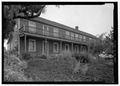 | 5 110×3 683 (17,95 Mo) | Fæ | GWToolset: Creating mediafile for Fæ. HABS 3 July 2014 (201:300) |
Paginas que contenon lo fichièr
La pagina çaijós compòrta aqueste imatge :