
Fichièr:Canada provinces evolution-250.gif
Pas de resolucion mai nauta de disponibla.
Canada_provinces_evolution-250.gif (250 × 216 pixèl, talha del fichièr: 211 Ko, tipe MIME: image/gif, en bocla, 18 imatges, 54 s)
| Aqueste fichièr proven de Wikimedia Commons?. Las informacions que lo concernisson son afichadas çaijós (procedura). |
Descripcion
| Descripcion |
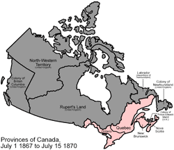
English: Scaled down version of Image:Canada provinces evolution.gif
An animated GIF of the evolution of Canada's internal borders, from the formation of the dominion to the present. PINK Province BROWN Territory GRAY Foreign land FUCHSIA Disputed land |
||||||
| Font | Trabalh personal | ||||||
| Autor | Made by User:Golbez. | ||||||
| Autras versions |
|


Publicat jos licéncia(s)
Aqueste fichièr es jos licéncia Creative Commons licéncia generica atribucion 2.5
- Sètz liure :
- de partejar – de copiar, distribuir e transmetre aquesta òbra
- d'adaptar – d'adaptar aquesta òbra
- Jos las condicions seguentas :
- atribucion – Vos cal atribuir aquesta òbra amb lo biais especificat per l'autor o lo concedent (mas pas dins un sens que suggerís que vos apròvan o qu'apròvan l'utilizacion d'aquesta òbra).
Istoric del fichièr
Clicar sus una data e una ora per veire lo fichièr tal coma èra a aqueste moment
| Data e ora | Miniatura | Dimensions | Utilizaire | Comentari | |
|---|---|---|---|---|---|
| actual | 6 novembre de 2006 a 23.05 | | 250×216 (211 Ko) | Qyd | Scaled down version of Image:Canada provinces evolution.gif An animated GIF of the evolution of Canada's internal borders, from the formation of the dominion to the present. Pink = provinces; brown = territories; gray = foreign lands; kinda fuschia |
Paginas que contenon lo fichièr
La pagina çaijós compòrta aqueste imatge :
Usatge global del fichièr
Los autres wikis seguents utilizan aqueste imatge :
- Utilizacion sus be-tarask.wikipedia.org
- Utilizacion sus be.wikipedia.org
- Utilizacion sus en.wikipedia.org
- Utilizacion sus fa.wikipedia.org
- Utilizacion sus lez.wikipedia.org
- Utilizacion sus ru.wikipedia.org