
Fichièr:Bodhitree.jpg

Talha d'aquesta previsualizacion: 400 × 600 pixèls. Autras resolucions : 160 × 240 pixèls | 320 × 480 pixèls | 512 × 768 pixèls | 682 × 1 024 pixèls | 1 365 × 2 048 pixèls | 3 072 × 4 608 pixèls.
Fichièr d'origina (3 072 × 4 608 pixèl, talha del fichièr: 4,14 Mo, tipe MIME: image/jpeg)
| Aqueste fichièr proven de Wikimedia Commons?. Las informacions que lo concernisson son afichadas çaijós (procedura). |
Descripcion
| Descripcion |
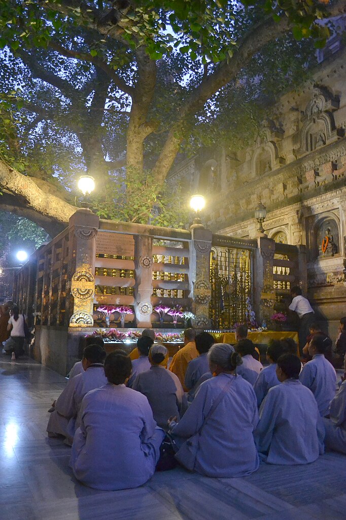
ไทย: พระแท่นวัชรอาสน์ใต้ร่มอัสสัตถพฤกษ์ในพุทธคยา (อุรุเวลาเสนานิคม) ที่พระพุทธองค์ประทับนั่งตรัสรู้พระอนุตตรสัมมาสัมโพธิญาณ
ถ่ายที่: พุทธคยา รัฐพิหาร ประเทศอินเดีย English: The Vajrashila, where the Buddha sat under the Bodhi Tree in Bodh Gaya, India. |
| Font | Trabalh personal |
| Autor |
ผู้สร้างสรรค์ผลงาน/ส่งข้อมูลเก็บในคลังข้อมูลเสรีวิกิมีเดียคอมมอนส์ - เทวประภาส มากคล้าย |
| Permission (Reütilizacion d'aqueste fichièr) |
Aqueste fichièr es jos licéncia Creative Commons licéncia generica atribucion-partiment a l'identic 3.0
English: This work was created by Tevaprapas. Please notify me if you use my work outside Wikimedia.
Français : Cette oeuvre a été crée par Tevaprapas. Veuillez me notifier si elle est utilisée à l'extérieur de Wikimedia.
Svenska: Detta verk skapades av Tevaprapas. Var vänlig kontakta mig om du använder detta verk utanför Wikimedia.
ไทย: งานนี้สร้างสรรค์โดย Tevaprapas ถ้าหากท่านประสงค์นำงานนี้ไปใช้นอกวิกิมีเดีย สามารถนำไปใช้ได้ภายใต้สัญญาอนุญาตที่กำหนดด้านบน หากผู้ใดนำผลงานนี้ไปใช้ กรุณาแจ้งเจ้าของผลงานเพื่อให้รับทราบด้วย
Македонски: Творец на ова дело е корисникот Tevaprapas. Известете го ако сакате да ги користите неговите дела вон Викимедија.
|
| Re-use | If you use this image outside of the Wikimedia projects, I'd be happy to hear from you. If you want a license with the conditions of your choice, please email me to negotiate terms. |
| Posició de la càmera | | Aquesta i altres imatges properes a: OpenStreetMap |
|---|
Istoric del fichièr
Clicar sus una data e una ora per veire lo fichièr tal coma èra a aqueste moment
| Data e ora | Miniatura | Dimensions | Utilizaire | Comentari | |
|---|---|---|---|---|---|
| actual | 24 novembre de 2011 a 18.45 | | 3 072×4 608 (4,14 Mo) | Tevaprapas | == {{int:filedesc}} == {{User:Tevaprapas/Information |Description={{th|'''[[:th:พุทธคยา|พระแท่นวัชรอาสน์ใต้ร่มอัสสัตถพฤกษ์ในพุทธคยา (อุรุเว� |
Paginas que contenon lo fichièr
La pagina çaijós compòrta aqueste imatge :
Usatge global del fichièr
Los autres wikis seguents utilizan aqueste imatge :
- Utilizacion sus af.wikipedia.org
- Utilizacion sus as.wikipedia.org
- Utilizacion sus bg.wikipedia.org
- Utilizacion sus en.wikipedia.org
- Utilizacion sus en.wikiquote.org
- Utilizacion sus fi.wikipedia.org
- Utilizacion sus hr.wikipedia.org
- Utilizacion sus kn.wikipedia.org
- Utilizacion sus rm.wikipedia.org
- Utilizacion sus sl.wikipedia.org
- Utilizacion sus ts.wikipedia.org