
Fichièr:New Brunswick-map.png
Pas de resolucion mai nauta de disponibla.
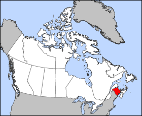
New_Brunswick-map.png (280 × 230 pixèl, talha del fichièr: 14 Ko, tipe MIME: image/png)
| Aqueste fichièr proven de Wikimedia Commons?. Las informacions que lo concernisson son afichadas çaijós (procedura). |
Map of New Brunswick
Projection: Wideload azimuthal equal-area
Geospatial data from: The Atlas of Canada, The National Atlas of the United States and U.S. Geological Survey
Cartographer: John Fowler
| Jo, el titular del copyright d'aquesta obra, l'allibero al domini públic. Això s'aplica a tot el món. En alguns països això pot no ser legalment possible, en tal cas: Jo faig concessió a tothom del dret d'usar aquesta obra per a qualsevol propòsit, sense cap condició llevat d'aquelles requerides per la llei. |
Istoric del fichièr
Clicar sus una data e una ora per veire lo fichièr tal coma èra a aqueste moment
| Data e ora | Miniatura | Dimensions | Utilizaire | Comentari | |
|---|---|---|---|---|---|
| actual | 24 març de 2005 a 12.13 | | 280×230 (14 Ko) | Voyager | Map of New Brunswick Projection: Lambert azimuthal equal-area Geospatial data from: [http://atlas.gc.ca/ The Atlas of Canada], [http://www.nationalatlas.gov/ The National Atlas of the United States] and [http://www.usgs.gov U.S. Geological Survey] Cart |
Paginas que contenon lo fichièr
La pagina çaijós compòrta aqueste imatge :
Usatge global del fichièr
Los autres wikis seguents utilizan aqueste imatge :
- Utilizacion sus bat-smg.wikipedia.org
- Utilizacion sus br.wikipedia.org
- Utilizacion sus cy.wikipedia.org
- Utilizacion sus de.wikipedia.org
- Utilizacion sus en.wiktionary.org
- Utilizacion sus eo.wikipedia.org
- Utilizacion sus es.wikipedia.org
- Utilizacion sus frr.wikipedia.org
- Utilizacion sus fr.wikinews.org
- Utilizacion sus gd.wikipedia.org
- Utilizacion sus hr.wikipedia.org
- Utilizacion sus hu.wikipedia.org
- Utilizacion sus hu.wiktionary.org
- Utilizacion sus io.wikipedia.org
- Utilizacion sus ko.wikipedia.org
- Utilizacion sus kw.wikipedia.org
- Utilizacion sus lij.wikipedia.org
- Utilizacion sus mk.wikipedia.org
- Utilizacion sus ms.wikipedia.org
- Utilizacion sus pam.wikipedia.org
- Utilizacion sus pl.wikipedia.org
- Utilizacion sus pms.wikipedia.org
- Utilizacion sus sc.wikipedia.org
- Utilizacion sus sh.wikipedia.org
- Utilizacion sus ta.wikipedia.org
- Utilizacion sus uk.wikipedia.org
- Utilizacion sus vo.wikipedia.org
- Utilizacion sus xmf.wikipedia.org
- Utilizacion sus zh-min-nan.wikipedia.org