
Fichièr:Ash and Steam Plume, Soufriere Hills Volcano, Montserrat.jpg
Fichièr d'origina (2 598 × 2 039 pixèl, talha del fichièr: 1,61 Mo, tipe MIME: image/jpeg)
| Aqueste fichièr proven de Wikimedia Commons?. Las informacions que lo concernisson son afichadas çaijós (procedura). |
Descripcion
| Descripcion |
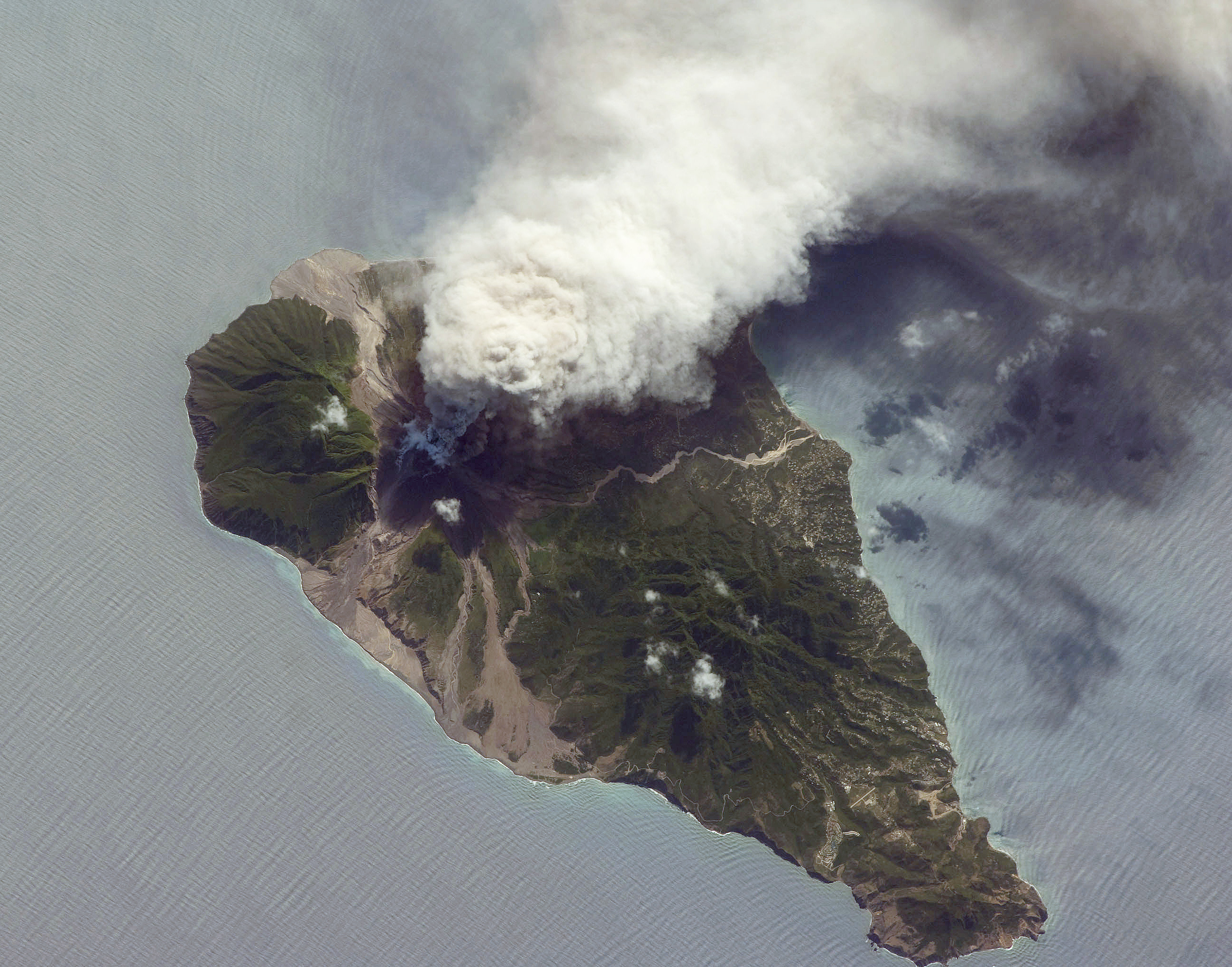
English: This oblique astronaut photograph from the International Space Station (ISS) captures a white-to-grey ash and steam plume extending westwards from the volcano. Oblique images are taken by astronauts looking out from the ISS at an angle, rather than looking straight downward toward the Earth (a perspective called a nadir view), as is common with most remotely sensed data from satellites. An oblique view gives the scene a more three-dimension quality, and provides a look at the vertical structure of the volcanic plume. While much of the island is covered in green vegetation, grey deposits that include pyroclastic flows and volcanic mud-flows (lahars) are visible extending from the volcano toward the coastline. When compared to its extent in earlier views, the volcanic debris has filled in more of the eastern coastline. Urban areas are visible in the northern and western portions of the island; they are recognizable by linear street patterns and the presence of bright building rooftops. The silver-grey appearance of the Caribbean Sea surface is due to sun-glint, which is the mirror-like reflection of sunlight off the water surface back towards the hand-held camera on-board the ISS. The sun-glint highlights surface wave patterns around the island.
|
||||||||||||||||||||||||||||||||||||||||||||||||||||||
| Data | |||||||||||||||||||||||||||||||||||||||||||||||||||||||
| Font | NASA Earth Observatory | ||||||||||||||||||||||||||||||||||||||||||||||||||||||
| Autor | Image taken by the NASA Expedition 21 crew | ||||||||||||||||||||||||||||||||||||||||||||||||||||||
| Posició de la càmera | | Aquesta i altres imatges properes a: OpenStreetMap |
|---|
Aquest fitxer ha estat catalogat per Johnson Space Center dels Estats Units d'Amèrica per a l'Administració Nacional d'Aeronàutica i de l'Espai (NASA)en virtut identificat com a: ID del fitxer : ISS021-E-5555.Els ID dels fitxers i ID alternatius són traduïts de Photo ID .Aquesta etiqueta no indica l'estat dels drets d'autor de la imatge carregada. Cal un senyal de drets d'autor. Vegeu Commons:Sobre les llicències. Altres idiomes:
|
Image acquired with a Nikon D2Xs digital camera fitted with a 400 mm lens, and is provided by the ISS Crew Earth Observations experiment and Image Science & Analysis Laboratory, Johnson Space Centre.
Publicat jos licéncia(s)
| Aquest fitxer és en el domini públic perquè ha estat creat per la NASA. L'avís legal de la NASA diu que «el material de la NASA no està protegit per copyright si no es diu el contrari». (NASA copyright policy page o JPL Image Use Policy). | ||
 |
Atenció:
|
Istoric del fichièr
Clicar sus una data e una ora per veire lo fichièr tal coma èra a aqueste moment
| Data e ora | Miniatura | Dimensions | Utilizaire | Comentari | |
|---|---|---|---|---|---|
| actual | 19 octobre de 2009 a 10.26 | | 2 598×2 039 (1,61 Mo) | Originalwana | {{Information |Description={{en|1=This oblique astronaut photograph from the International Space Station (ISS) captures a white-to-grey ash and steam plume extending westwards from the |
Paginas que contenon lo fichièr
Las paginas çaijós compòrtan aqueste imatge :
Usatge global del fichièr
Los autres wikis seguents utilizan aqueste imatge :
- Utilizacion sus de.wikipedia.org
- Utilizacion sus el.wikipedia.org
- Utilizacion sus en.wikiversity.org
- User:Marshallsumter/Radiation astronomy1/Planets/Sciences
- Draft:Keynote lectures/Satellites for radiation astronomy
- Draft:Original research/Astrogeology
- Planets/Geology
- User:Marshallsumter/Radiation astronomy2/Rocks
- Gases/Gaseous objects/Earth
- Radiation/Astronomy
- User:Marshallsumter/Radiation astronomy2/Satellites
- User:Marshallsumter/Radiation astronomy2/Reflections
- User:Marshallsumter/Radiation astronomy/Earth
- Orbital platforms
- Utilizacion sus fr.wikipedia.org
- Utilizacion sus hy.wikipedia.org
- Utilizacion sus no.wikipedia.org
- Utilizacion sus ru.wikipedia.org